A series of articles that I have written on Port Phillip Bay, appears to be very popular with readers. Apart from updating the post Shipwrecks in Port Phillip Bay with new content, I am planning to write a few more articles for the series. However, I have decided to jump to the last article now and fill in the rest later.
I have described in this post how Port Phillip Bay was formed by rising sea levels flooding the plains at the end of the last Ice Age. Research from the University of Melbourne using new geological data showed that 2800 years ago, the bay entrance became blocked with sand and silt, cutting it off from Bass Strait (Ref 1). With no ocean water to replenish it, the bay slowly dried out and shrunk, leaving a small, salty lake of no more than one-third the current size 1000 years ago. Yarra and Werribee rivers meandered across a dry, flat surface covered with grasses and salt bush to reach this lake. Evidence of these can be seen from the little channels left behind by the rivers on the bay floor today. Some big storms or even an earthquake might have unclogged the blockages, resulting in a sudden influx of sea water from Bass Strait. An aboriginal legend of a catastrophic ocean flooding filling the Bay within days lends support to this theory. A multibeam sea-floor survey had captured the image of a possible erosion channel created by sudden water influx.
What is the chance of Port Phillip Bay becoming a lake again? Dr Holdgate who conducted the research said this is unlikely as blockages would be prevented by regular dredging to allow passage of container ships. I think we should not discount the possibility this may happen again, not as a result of natural processes but due to human actions. This will take the form of a dam built across the bay entrance, creating an enclosure of water.
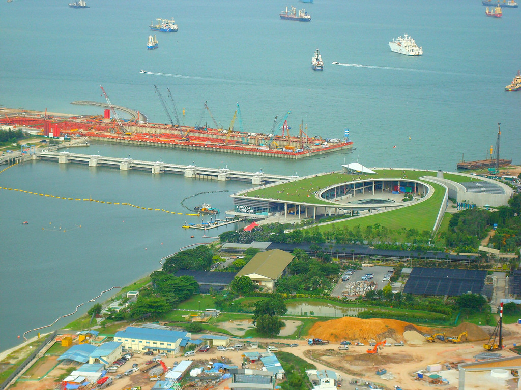
Like Melbourne, Singapore is facing problems of securing long-term reliable water supplies. Singapore is located in the tropics and has high annual rainfalls. But its land scarcity limits it from building more reservoirs. Singapore pursues a 4-tap strategy to become self-sufficient in its water supply and to reduce its reliance on water imported from Malaysia under 2 treaties due to expire in 2011 and 2061. An innovative S$226 million project turns Marina Bay and Kallang Basin into Marina Reservoir, Singapore’s 15th reservoir and its first downtown reservoir by damming the mouth of Marina Bay. The dam called Marina Barrage was completed in 2008 and Marina Reservoir started operations in Nov 2010 after becoming freshwater through a process of natural desalination, when excess water was released out to the sea after heavy rains. The new reservoir provides water supply, flood mitigation and a constant water level conducive to aquatic recreational activities.

Photo of Marina Barrage by linkway88
Will Melbourne emulate Singapore’s example for the same reason? I think this is unlikely. Firstly, Victoria has no lack of land to build more reservoirs. The problem here is the long-term trend of low rainfall in Melbourne. We see exceptional amounts of rain this year due to the La Nina phenomenon. But as at 1st July 2011, Melbourne’s water storage achieves only slightly more than half its capacity, at 56.5%, despite the continuous rains.
Secondly, the water needs have been addressed by the construction of the A$3.5 billion Wonthaggi Desalination Plant and the now dormant North-South or Sugarloaf Pipeline. These costly projects have been criticized as a knee-jerk reaction to a few years of drought by a panicked government. It remains to be seen whether they are justifiable and whether cheaper alternatives such as water recycling and rainwater collection will suffice.
Thirdly, the bay entrance provides a vital open channel for ships to enter the bay for travelling to Melbourne Port, which is Australia’s biggest container port, handling more than 35% of its trade. There has been ongoing suggestions to move Melbourne Port to Hastings (see post) but this requires massive infrastructure investments, may disrupt logistics operations and carries political risks.
Lastly, the isolation of the water is certainly going to impact upon the existing marine ecosystems. Fish such as snappers will no longer be able to carry out their annual migrations into the Bay from Bass Strait. Marine organisms will die in a freshwater environment. Even if no seawater is pumped out into Bass Strait, the salinity level may still change. The water will gradually be populated by new species but this will take time. The enclosed water may accumulate wastes discharged from the rivers and sewers, thereby polluting the water. Thus, if the Bay is to be dammed, it is not for the purpose of creating a freshwater reservoir. Rather it is due to something far more compelling.
In late 2009, the Federal Government released high-resolution maps showing which coastal areas along Australian coast will be inundated by sea-level rises as a result of global warming (Ref 1, 2, 3, 4, 5). The maps show projected inundation for rises of 50 cm, which are probably unavoidable, 80 cm and 1.1 m by 2100 (Ref 3). Coastal flooding seen in Australia once every 100 years today, could occur several times a year by 2100 (Ref 6) and a rise of as high as 1.5 m cannot be ruled out (Ref 7).
In Victoria, 45,000 coastal homes, worth $10.3 billion, in the municipalities of Kingston, Hobsons Bay, Greater Geelong, Wellington and Port Phillip are considered the most at risk.
| Local Government Area | No. of houses at risk |
|---|---|
| Kingston | 9000 |
| Hobsons Bay | 7500 |
| Greater Geelong | 6599 |
| Port Phillip | 3600 |
Evidence suggests that by 2100, St Kilda and Middle Park beaches would be lost to erosion caused by sea level rise. Parts of the St Kilda foreshore, including Luna Park and Acland Street, would be flooded by severe storm surges caused by climate change (Ref 1).
Rising sea levels do not impact just only on coastal areas but will also cause flooding along the Maribyrnong River and Yarra River, threatening suburbs such as Footscray, Flemington, Docklands and Yarraville, affecting homes, shopping areas, offices, industries, roads and railway lines (Ref 2).
Click here to view the sea level rise maps for the Melbourne region, prepared by Geoscience Australia. I have embedded the worst scenario map of 1.1 m rise for the Hobsons Bay region in the year 2100 below. The blue colours indicate the inundated areas. Zoom in/out using the +/- buttons or your mouse’s scrolling wheel and the drag the map around to look at the details.
Source: OzCoasts
If Port Phillip Bay becomes polluted by oil leaking from the flooded Mobil Oil Refinery at Altona as depicted in the sea-level rise map above, the consequences will be devastating to the whole of Melbourne and not just limited to Hobsons Bay.
One potential way to protect habitable places in Port Phillip Bay from inundation is to adopt the Dutch strategy of building dykes to keep out seawater from low-lying areas. I believe the cheapest and easiest way to offer protection to a large geographical area within Port Phillip Bay is to dam the entrance. This will keep out the rising seawater from Bass Strait. Other alternatives will either to build a series of dykes around Port Phillip or to abandon the flooded areas. Imagine a future Atlantis with houses, buildings and roads fully or partially submerged under water! Avoiding a catastrophe may override environmental concerns and shipping needs at that point of time.
There could be other side benefits as a result of damming. Road and rail could be constructed above the dam, directly linking Mornington and Bellarine Peninsula. By shunting the need to go through Melbourne, it will be a breeze to travel between these two regions. This will in turn open up new economic opportunities. Lake Phillip may be kept either saline or converted to a freshwater reservoir providing a massive 25 km3 of water (equivalent to 12 Lake Eildons), which is fed by a large and geographically-dispersed water catchment area of 9790 km2. Tidal power could be harnessed from the damming, involving the building of a power station of around 1.6MW, similar to Hazelwood and requiring no cooling water (Ref 8). The shutting of the open shipping channel at the bay entrance will necessitate the moving of Melbourne Port to Hastings, thereby freeing up valuable inner city space for residential and commercial developments, and unclogging the roads and freeways of trucks.
History could repeat itself with Port Phillip Bay turning into Lake Phillip in the future, not due to natural geological processes but as a consequence of human actions, namely global warming induced by human activities and the consequent need to mediate the effects of sea level rise.


A couple of points, Anthony.
It is highly unlikely that Mobil Refinery will still be around by the time rising sea levels become a real concern. The refinery is a very old plant and it's more than likely our refined products will be coming from an Asian refinery, that is if there is anything left to refine!
Building a dam at the entrance to the bay would be just swapping one man made environmental disaster for another. The amount of water taken from the rivers feeding into the bay leading to very reduced flows combined with natural evaporation would leave the bay something like the Dead Sea, a hyper saline lake with nothing but a few hardy organisms. As the bay is only about 24 mts at its deepest point, the lake shore would end up as a salty wasteland, something like the polluted wasteland around the Aral Sea.
Although there is plenty of land, a reservoir is not much use unless it is fed with a source of water. I would have thought that with all the information and discussion over the last few years, the idea of new reservoirs would have been buried. The only river in Victoria without some sort of dam or weir to capture water is the Mitchell River as far as I know. It has been investigated but apparently the cost of a dam, in both the money and environmental cost, would far outweigh the quantity and value of the water.
Thanks for the information all the same, Brian.
Thanks for your good points. Hope that the Refinery will be long gone by that time! I envisage the dam affording more control, or bidirectional control, keeping out rising sea water but also having the flexibility of allowing in more seawater from Bass Strait, depending on the water level in the Bay. Hopefully science and technology will be advanced by that time so that this will not be a technical difficulty.
There can only be bi-directional control if you can move the water in the bay out to the open sea, but if sea levels have risen to the extent where a dam would be necessary, then the only way you could move water out of the bay would be by pumping. Simply allowing water into the bay to control the bay water level would increase the salinity of the remaining water as it evaporated.
The science and technology exist now but instead of using it to overcome these problems, we should be using it to minimise the causes.