An old map of Altona shows a proposed extension of the Altona Rail Line from Altona station to Point Cook in the year 1928. This was one of three options, the other two being extending the line from the Altona Beach station (just east of the current Grieve Parade) to a proposed station called “Edinburgh” or to Laverton. The Altona Line was eventually extended to a new station named Westona on 21 Jan 1985 and then to Laverton on 11 April 1985.

Note: Lily St is the current Grieve Parade
If the line to Point Cook has been built too, it will have serviced the sprawling suburb of Point Cook and can be further extended to Point Cook West and the planned super suburb of East Werribee – a 770-hectare site with more than 7000 new houses, 20,000 residents and 50,000 jobs (Ref 1, 2).
I think the idea of having a Point Cook Line would have crossed the minds of many people. Is this wishful thinking or is this line “doable” perhaps not now but something to look forwards to in the future? I do not have the answer. But I will now conduct a theoretical exercise to examine this possibility from different angles.
Justification based on Population Growth
Building rails is expensive and it can only get more expensive, unless technology changes. Hence, the need for sufficient population to justify new rail lines.
Wyndham is the fastest growing area in Australia and within Wyndham itself, the fastest growing area is Point Cook (Ref 3). According to Wikipedia, Point Cook has a population of 32,413 in 2011 and this is estimated to reach 50,246 by 2020 and to peak at around 60,000 by the late 2020s. Doncaster and Rowville, where new train lines have been lobbied for years, have populations of 18,359 and 34,145 in 2011 respectively. Doncaster and Rowville are pretty matured residential areas so their growth rates will not be as spectacular as that of Point Cook. I do not know whether the population estimate of Point Cook includes the 5800 residents projected in Point Cook West and those along Point Cook Homestead Road. Add all these numbers to the forecasted 20,000 residents in East Werribee and you get a massive population hub south of the Princes Freeway/Highway.
Justification based on Traffic Congestion
You may say that Point Cook is already served by Aircraft, Laverton as well as Williams Landing station due to open in 2013. In addition, the Baillieu government has flagged the possibility of building a train station at Derrimut Road between Hoppers Crossing and Werribee stations to serve the East Werribee precinct. Point Cook would hence appear well-serviced to people from outside the area. This is far from the reality.
To get to Aircraft or Laverton, residents need to cross over M1 from Point Cook Road which has only one lane in each direction for most if not its entire length. Residents may need to take up to an hour to reach Princes Freeway during peak hours due to the gridlocked traffic (Ref 4, 5, 6). According to Wyndham Council’s 2011 traffic volumes report, Point Cook Road is running over capacity, carrying 21,100 vehicles a day. It has been in fact voted this year as the third most congested road in the RACV Redspot Survey (Ref 7). Yet VicRoads says it has no plans to duplicate Point Cook Road (Ref 8). The complicated roundabout between Point Cook Road and the overpass, which feeds roads in all directions, only serves to make the traffic worse.
When the new Williams Landing station opens in 2013, Point Cook residents will still need to cross M1 via the Palmers Road overpass to access the station. Some cars that originally travel to Aircraft or Laverton via Point Cook Road will be diverted to this route and the new train station, thereby helping to ease congestion in Point Cook Road. I believe there will be a new road that runs from Williams Landing station to Aircraft, then to Laverton. Some cars will use this new road instead of Point Cook Road to travel to Laverton station. As the population grows, Palmers Road will likewise face congestion and need to be duplicated eventually.
The State Government has announced under the East Werribee precinct plan, its commitment to a $40 million Princes Freeway diamond interchange at Sneydes Rd, which is funded by proceeds from the sale of land. Planning Minister Matthew Guy said the construction of the full Sneydes Road interchange is a major breakthrough in improving the liveability of Point Cook and the viability of the new East Werribee precinct (Ref 9, 10).
You can see the location of the Sneydes Road interchange from the map below. This interchange will no doubt be essential to East Werribee and Point Cook West. But for other parts of Point Cook, cars heading for the city will in fact have to drive (for a considerable distance from some areas) in the direction away from the city to access this interchange. Hence, Point Cook Road, Palmers Road and Boardwalk Boulevard will still remain the roads of choice for getting to M1 and the city for the majority of Point Cook residents. Where driving to the train station is concerned, the Sneydes Road exit is out of the way unless you want to drive via Hoppers Lane to Hoppers Crossing station to catch the train.
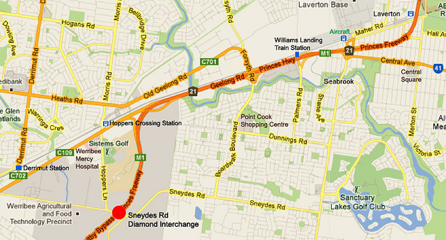
You can also see from the same map, commuters from the new East Werribee Precinct will need to cross the busy Princes Highway/Geelong Road in order to access Hoppers Crossing or Derrimut train stations. Currently, drivers face acute traffic jams around Hoppers Crossing station as well as other stations on the Werribee line. Cars coming from the housing estates have to access the same roads (e.g. Morris Road in Hoppers Crossing and Point Cook Road) for either travelling to the City or to the train station. This is the legacy of siting the rail and freeway next to each other.
Thanks to the East Werribee Precinct development, Hoppers Crossing station may become the busiest on the Werribee line. To improve the traffic flow which is vital for the success of this precinct, I will like to suggest the following:
- Remove the level crossing at Morris Road through grade separation.
- Build a flyover on Princes Highway so that Hoppers Lane connects directly to Morris Road through an underpass to allow for uninterrupted traffic flow from the new precinct to the train station.
I think the liveability of Point Cook and the viability of the East Werribee Precinct will be improved tremendously if a new rail line runs through the heart of these growth areas, much more than what could be achieved by the Sneydes Road interchange alone. This new rail line will remove the need for:
- train passengers to drive across the Princes Freeway and Highway, thereby greatly reducing the traffic congestion during peak hours.
- building many more car parking spaces at existing train stations to accommodate the huge increase in population.
If the current road congestions and parking woes at train stations are any indicator, things will get only much worse with a greatly-boosted resident and employment population base.
East Werribee Employment Precinct
The yet-to-be named “East Werribee Employment Precinct” is spruiked by Premier Ted Baillieu as ”the capital of the new west”, providing employment for 50,000 people and homes to 20,000 residents (Ref 11, 12). With an area more than that of Melbourne CBD and Docklands combined, it is touted by Planning Minister Matthew Guy as the largest integrated business and residential development of government-owned land in Victoria since Docklands.
Planning experts warned that without an early investment in good public transport, the government’s vision for the new suburb would fail. ”I don’t know of any alternative jobs cluster in the world which might be located 35 to 40 minutes from the CBD and doesn’t even have a train station,” said Dr. Chris Hale, a transport strategist at Melbourne University. He said Parramatta was evolving into a successful alternative CBD because it was a short 15-minute train ride from central Sydney (Ref 13).
Melbourne University planning expert Alan March said the suburb’s new residents would be consigned to car-dependency. ”Making a car-based employment hub seems like a very outdated idea and I’m frankly surprised that we are continuing to do that,” Dr March said.
I would think an area of such economic importance should provide even stronger justification for an alternative rail line that could directly serve its transport needs and help to foster its development.
Technical Feasibility
My preferred route is the branching of the Werribee line at Westona southwest to Altona Meadows with a station at Central Square before continuing to Point Cook, Point Cook West and East Werribee. There could be several stations on this extension, including one at Point Cook Shopping Centre and one near Point Cook Road.
I believe no land has been reserved for heavy rail, which I think reflects a lack of foresight. Point Cook is a huge area and I believe its population forecast has already been made at the planning stage. The only viable and efficient way of transporting large numbers of people in and out of a large suburb is via rail. The rail is the “dorsal aorta – main coronary artery” of the suburb through which large numbers of people (the “blood” and “oxygen“) can be moved rapidly and efficiently. If you are going to have only roads (the “arteries and veins“), you are going to clog them up when the cars (the “fats“) become too abundant. What you will eventually get is a failed “heart“. So a lifeline (the “rail“) is absolutely essential.
There may be no money to build the rail back then or the rail is not justified by the small starting population base. What the planning authority could have done is at least to reserve lands, so that rail can be built whenever that becomes viable.
Building a rail line through built-up areas is possible but is expensive as this would probably involve:
- the acquisition of properties
- elevating the train track or
- making the train line runs underground.
When the train lines were first built in Singapore, I was puzzled at how space was going to be found from the existing roads to accommodate the train tracks. The subsequent engineering feats that accomplished this task have since changed my thinking that everything is possible. A classic example is that a road may have some median or side nature strip, which will not be wide enough to accommodate a train station or even the train tracks. A clever strategy was to build pillars on these nature strips which support collars through which elevated train tracks run through. It will be cheapest to build train tracks on the same level as the road. But this will run into problems of creating level crossings, which may turn out to be more expensive to remove in the future. The high initial investment put into building elevated tracks will achieve grade separation, once and for all.
Exploring the Alternatives
To be fair to the planner, lands were already reserved for light rail according to the Point Cook Concept Plan. Nothing is mentioned about the route in this Concept Plan and whether it connects with the East Werribee Precinct. I also do not know what are the relative merits and demerits between light and heavy rails but my guess is that light rail is slower, has more stops, takes lesser people per train car and requires connection to a heavy rail for onward journey to the City or Werribee.
Another less costly proposal that could be launched now is to have a frequent and reliable network of bus services to the train stations. The major problem with buses is that they are too stuck in traffic jams. In addition, it may take a long commuting time from one’s home to the train station and vice-versa due to the meandering route that a bus takes and the many stops it makes. Coupled with its low frequency and unreliable timings, taking buses would be a very frustrating option for many residents.
Point Cook is pretty isolated, with its current connections with the “outside world” primarily through three roads: Point Cook Road, Palmers Road and Boardwalk Boulevards. Hence, I hold the opinion that a new line is the best way forwards for this southwestern part of Melbourne.
Funding
The greatest obstacle to the construction of new rail lines in Melbourne or any other place in Australia is the funding problem. Melbourne has not had a significant suburban railway expansion since 1927 when the Glen Waverley railway line was constructed.
The prospect is grim considering this long list of more urgent/prioritized transport projects:
- Melbourne Metro
- East-West Road Connection
- Second river crossing and WestLink
- Removal of level crossings
- Electrification of existing tracks such as to Melton
- Duplication of single tracks
- Road duplication
- Doncaster Line
- Rowville Line
- Rail link to Melbourne Airport
- Rail link to Avalon Airport
- Completion of the Metropolitan Ring Road
- Outer Ring Road
Suggestions on how to pay for new rail lines are few. Public transport advocates have questioned the priorities accorded to roads rather than rail. The thinking is that money budgeted for road construction would take away from the limited pool that can otherwise be used to fund rail projects. There have been suggestions of adopting the Private-Public Partnership (PPP) model that was used to build tollways such as CityLink and Eastlink to that of constructing rail lines. Apparently, there are a lot of difficulties inherent in such a funding model, such as convincing a private enterprise that this is a commercially-profitable investment and getting good value for taxpayers at the same time.
Recently, a private consortium is seeking a $600 million to $700 million contribution from the State Government, as part of a bold $2 billion plan called the “Project Double Fault“, to build a new train line through a tunnel dug between the Glen Waverley and Dandenong railway lines. This will accommodate 6 new underground stations at Chadstone Shopping Centre, Heyington, Kooyong, Tooronga, Gardiner and Glen Iris. Burying part of the Glen Waverley line below ground will remove all its six level crossings, including two that intersect with tram lines, and free up valuable land for development. The Chadstone connection would spark a huge increase in rail patronage and help the government recoup its costs (Ref 14).
What appears most promising is identifying and exploiting the commercial opportunities presented by both old and new rail lines. Let me talk about the existing rail lines first. People and businesses are attracted to set up their homes and offices near train stations because of easy access, convenience, high human traffic and concentration of facilities and services. In many cities around the world, train stations are an integral part of commercial hubs, where they are embedded within highrise buildings. The State Government, through VicTracks, could make use of the valuable untapped airspace above train stations and land around train stations. These train stations could be redeveloped as part of a highrise building and the profits made from such undertakings could be channeled to a fund established for the purpose of rail expansion. Of course, one could expect a lot of community objections but think of the greater good that this will result. Actually, this funding model could be applied to new train stations as well so that new lines become partly “self-financed“.
Think of the following two scenarios: (A) Construct a building right on top of a train station and (B) Construct a building a driving distance away from a train station. Many more parking spaces (for the building plus the train station) will be probably be needed in the design for Scenario B. This is because many people would not have driven if public transport is easily accessible.
A recent report, jointly written by transport experts from Curtin University in Western Australia, Melbourne’s RMIT University, global engineering firm Arup, said that a railway line to Doncaster could be built for $840 million and paid for using taxes raised from the higher property values it would generate (Ref 15). In an article to The Age, John Legge estimated that $1.7 billion per year or $35 billion over 20 years could be raised from a rate of 0.1¢ in the unimproved capital value dollar. I think this suggestion should merit further exploration.
How should the development of Point Cook and East Werribee proceed? What will be the future of rail infrastructure and what are some of the possible directions? Please contribute your thoughts.


